Forged by Structure, Driven by Discovery
Southwestern Athabasca Basin | 4,670 ha | 100% Stallion Uranium Owned
Overview
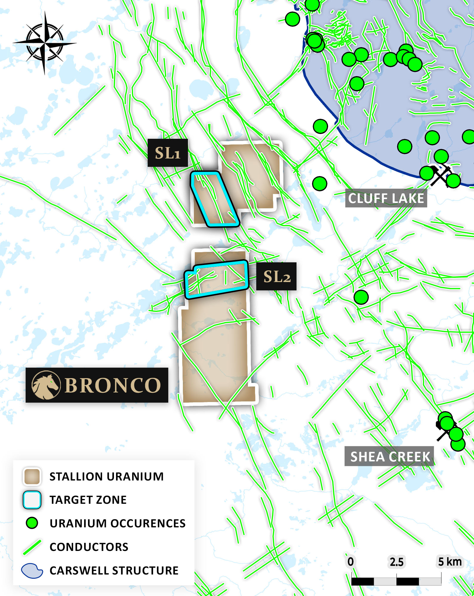
The Bronco Uranium Project spans three strategically located claim blocks totaling 4,670 hectares in the western Athabasca Basin. The project lies just 13 kilometres west of the historic Cluff Lake Mine, which produced over 62 million pounds of U₃O₈ between 1979 and 2002.
Positioned 6 km southwest of the Carswell Impact Structure, Bronco benefits from the unique geology created by a massive meteorite impact. This event generated a complex structural zone characterized by concentric ring faults and disrupted basement architecture — key features that enhance the potential for uranium mineralization.
These Carswell ring faults interact with NW-trending basement conductors that have been delineated across the Bronco Project. These conductors are sub-parallel to the Saskatoon Lake Conductor, a well-known mineralized system that hosts UEC’s Shea Creek Project, one of the largest undeveloped uranium deposits in the Basin.
The Bronco Project is one of the few areas in the Athabasca Basin that exhibits geological and structural characteristics seen at both the Cluff Lake Mine and the Shea Creek Deposits — combining elements of near-surface mineralization with deep-rooted basement-hosted systems. This convergence makes Bronco a standout target for high-impact uranium discovery.

Figure 1 - Bronco Project

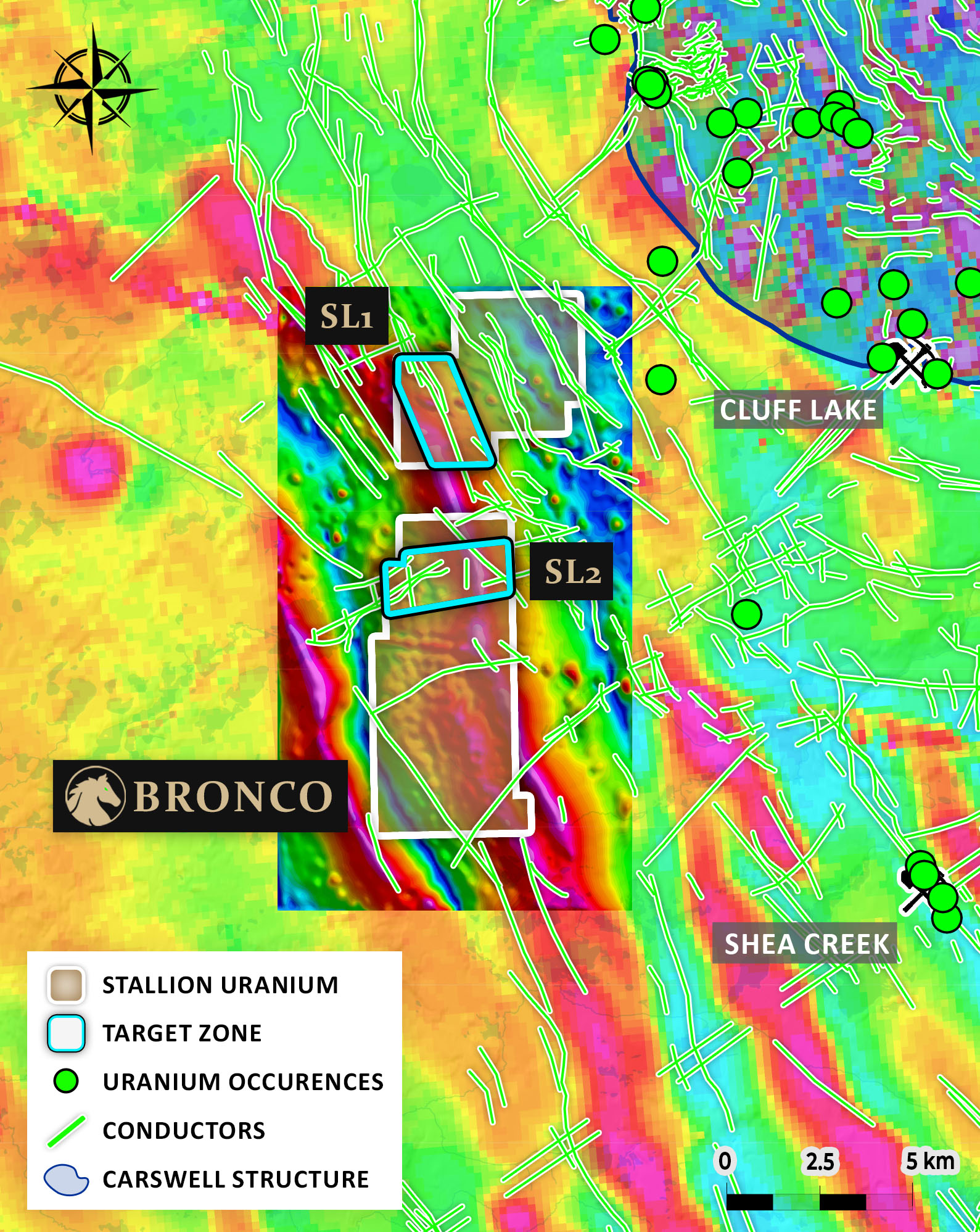
Figure 2 - Bronco Project - Magnetic Tilt Derivative over Magnetic First Vertical Derivative
Exploration Targets
SL1 Target
Located within the Bronco Uranium Project, the SL1 Target is a high-priority zone defined by a strong EM conductor corridor interpreted from airborne geophysics.
What sets SL1 apart is its position near the Carswell Impact Structure's southwestern margin, where complex ring fault interactions create structural traps and fluid pathways. This structural complexity, combined with graphitic conductor responses and magnetic breaks, suggests ideal conditions for basement-hosted uranium deposition.
Planned exploration includes follow-up geophysics and initial drill testing to confirm structural offsets, conductor depth, and potential alteration halos, aiming to define a new discovery in a setting that mirrors the Shea Creek mineralizing system.
SL2 Target
Also situated within the Bronco Uranium Project, the SL2 Target lies approximately 5 km southwest of SL1 along a NE-oriented structural corridor. SL2 is highlighted by a broad conductivity anomaly featuring multiple discrete EM conductors and subtle magnetic flexures — indicators of structural reactivation and potential fluid focus zones.
SL2 is particularly interesting due to the presence of an ENE-trending cross-fault, interpreted as a splay or dilation zone intersecting graphitic conductors. This geometry creates an optimal environment for uranium precipitation, reflecting conditions similar to both the Cluff Lake deposits and Shea Creek system.
With structural complexity, strong geophysical signatures, and proximity to known mineralized trends, SL2 will be advanced through detailed interpretation and prioritized for upcoming drilling alongside SL1.
Exploration Roadmap
The Bronco Uranium Project, located in a structurally complex and highly prospective corridor west of the Cluff Lake Mine and near the Carswell Impact Structure, is advancing through a focused, multi-phase exploration strategy. With a strong foundation of geophysical data and regional analogues like Shea Creek and Cluff Lake, the project is well-positioned for a potential basement-hosted uranium discovery.
- Deploy ground gravity to identify zones with potential uranium alteration
- Deploy targeted ground EM surveys (such as Fixed-Loop or Stepwise Moving Loop EM) over high-priority conductors.
- Complete gravity surveying to assist in identifying basement alteration zones associated with mineralization.
- Identify structural intersections and potential fluid trap zones where uranium may have concentrated
- Drill Program - Design initial scout drill holes to test the most compelling conductor/structure intersections at depth. Focus on areas with overlapping conductor responses, favorable structure, and lithological contacts.
